The North Herts District Council beautifully stewards the Great Ashby Woodlands and District Park, which is shared with and enjoyed by our friends in Stevenage, especially from Chells Manor, Chrysalis Park, St Nicholas & Woodfield (‘The Great Ashby Greater Area’).
This amenity welcome will soon be extended to East Herts District Council (EHDC) when the housing development at Gresley Park is built. Building is also planned to the North and North East of Great Ashby, meaning busier roads.
Friends of Greats Ashby (FoGA) helps keep the rights of way safe, by working on the Green Spaces Action Plan, litter picking, cutting vegetation and reporting issues, and offering to help resolve them.
FoGA also has a developing traffic and speed management campaign , to ensure that the Great Ashby Circular Walk can be enjoyed, of which the following should be noted:
- The Great Ashby Community Council started to develop a speed management policy in January 2019 Minute 1470, which is not full formed yet.
- Herts County Councillor Steve Jarvis started to invest in a safe crossing point at the junction of Serpentine Close and Great Ashby Way February 2019 Minute 1483 & June 2019 Minute 1548, which should be planned for next years budget.
- That the Bus stop at Round Diamond School could be adapted to be more accessible to those with physical challenges & to provide safer boarding on to the bus by travellers, and safer access around the parked bus by vehicles. This funding has been agreed February 2020 Minute 1686 , but no action has yet been minuted as taken.
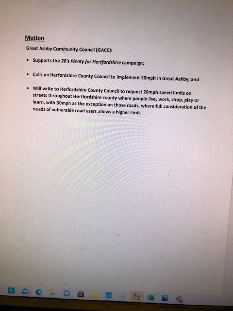
- A motion for the GACC to adopt a default 20mph speed limit on residential roads off main spine roads (like Great Ashby Way and Martins Way), has been put to the Great Ashby Community Council, noting with thanks that North Herts District Council (NHDC) has already adopted a ‘20’s Plenty’ where people are motion on 15th April 2021.
- These features are essential for adopting in the proposed housing development areas.
When 20’s plenty default limits are adopted, our Great Ashby Woodland Walk will be safer, as below and as the bus stop and crossing features are installed, we will be more safely be able to enjoy our walk.
See the map below coloured BLUE for safe roads and RED for those where even more caution is needed.
“Safer BLUE” roads; “More Caution need RED” roads.
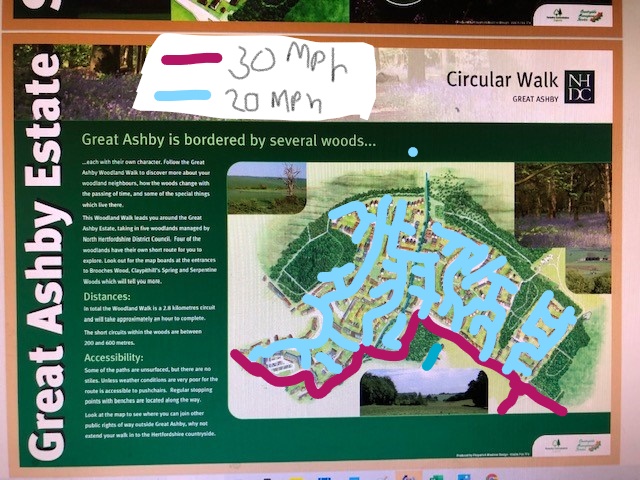
Map post safe 20’s Plenty implementation.
